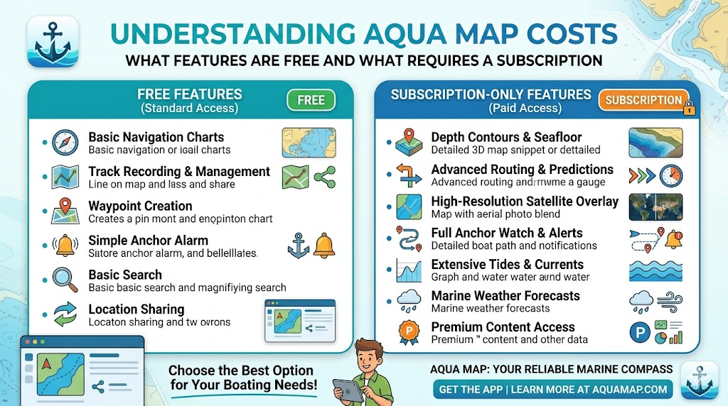
Marine navigation apps have shifted toward flexible pricing models, giving boaters the ability to pay only for the tools and chart regions they need. Instead of using a single all-inclusive subscription, Aqua Map uses a modular approach where charts and advanced tools can be purchased separately.
For boaters looking into aqua map pricing, understanding how the app is structured can help avoid confusion and prevent paying for features that may never be used. Aqua Map uses separate chart subscriptions and advanced feature subscriptions rather than bundling everything together.
The app itself is free to download
One of the first things many users notice is that downloading Aqua Map does not cost anything.
The free version provides access to basic functionality and allows users to explore the interface before committing to subscriptions. Aqua Map also offers a free trial period for subscriptions so users can test features before purchasing.
However, downloading the app alone does not unlock complete navigation functionality.
Charts are purchased separately
Aqua Map’s system revolves around chart subscriptions.
Users select chart regions depending on where they boat. These chart subscriptions provide:
- Official nautical charts
- Route planning capabilities
- Navigation markers and depth information
- Offline chart downloads
- Track recording features
Without chart subscriptions, users do not receive complete navigation coverage.
This setup can be helpful because a boater using only local waterways does not need to pay for worldwide coverage.
Advanced tools are a separate subscription
In addition to charts, Aqua Map offers advanced subscription tiers called Expert and Master.
The Expert subscription currently starts around $14.99 annually, in addition to chart costs.
Features available through advanced subscriptions can include:
- Marine weather overlays
- Route Explorer tools
- AIS integration
- Satellite imagery overlays
- External instrument connections
Master subscriptions add additional local data features in supported regions, such as specialized survey information.
Long-term cost depends on boating habits
The total cost can vary significantly depending on usage.
For example:
Occasional local boater
- Regional charts only
Weekend boater
- Regional charts + Expert tools
Long-distance cruiser
- Multiple chart regions + Master subscription
Someone boating only in one area could spend considerably less than users travelling across multiple regions or relying heavily on premium features.
Aqua Map still offers some purchase flexibility
Unlike some navigation apps that rely exclusively on recurring subscriptions, Aqua Map has historically offered lifetime chart purchase options for certain regions. Older chart offerings included options such as one-year access or permanent chart ownership depending on the chart package.
Some users appreciate this because it reduces concern about losing chart access if a subscription expires.
One App Store reviewer specifically highlighted the appeal of the “buy once” approach for charts.
How Aqua Map compares to traditional subscription models
Many navigation apps package all features into a single recurring plan.
Aqua Map takes a different approach:
Traditional model
- Single annual subscription
- Fixed feature bundle
Aqua Map approach
- Chart subscriptions selected by region
- Optional advanced tool subscriptions
- Greater customization
For some users, this flexibility lowers costs. For others, managing multiple subscriptions may feel more complicated.
Choosing the right setup
The best configuration often depends on how frequently you boat.
Basic users may only need:
- Local charts
More active boaters may benefit from:
- Chart subscriptions
- Weather overlays
- Route planning tools
Long-distance cruisers may want:
- Multiple chart regions
- AIS connectivity
- Advanced navigation data
Matching subscriptions to actual boating habits usually provides better value than selecting every available feature.
Final thoughts
Aqua Map pricing works differently than many marine apps because it separates navigation charts from advanced tools.
This approach gives boaters flexibility, but it also means total costs depend heavily on what features and chart regions are selected.
Rather than focusing only on the starting price, it helps to think about which tools will actually improve your time on the water and support the way you boat.